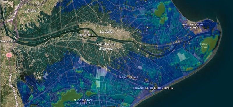
A coastal flood map catalogue was developed according to the Rapid Mapping approach described in Dottori et al. (2017). Areas prone to flooding were identified along the European coastline, using the Total Water Level (TWL) hindcast dataset, including the wave contribution to the TWL (Paprotny, 2018; Marcos et al., 2019), using the a high resolution European DEM (10×10 m) kindly provided by JRC. The work also incorporated previous analysis carried out by Vousdoukas et al. (2016).
In a second phase, these flood-prone coastlines were segmented into 50-100 km stretches, and LISFLOOD-FP was implemented with 25-50 m resolution. For each coastal segment a flood map catalogue was created, storing the results of several simulations. Each simulation was based on the ANYEU-SSL hindcast dataset corrected by the CMEMS hindcast, and accounting for local variability in the main factors that control coastal flooding (TWL, infiltration, event duration, etc.).
Finally, the ECFAS Expert System applies an algorithm to forecast the event-based flood extension on the basis of the coastal flood map catalogue similar to the current EFAS approach (Dottori et al., 2017).
The ECFAS Pan-EU Impact Catalogue collects impact layers associated to the flood scenarios contained in the ECFAS Pan-EU Flood Catalogue. Impacts associated with the flood maps were calculated following the approach described in the technical document of the ECFAS Deliverable 5.3 Algorithms for Impact Assessment (ECFAS Impact Tool; Duo et al., 2021). The ECFAS Impact Tool was adapted to assess the affected population, the damage to buildings, roads and railways and the exposure of a variety of other assets (e.g. agriculture, points of interest, etc.) for the flood scenarios included in the ECFAS Flood Catalogue.
References:
Dottori, F., Kalas, M., Salamon, P., Bianchi, A., Alfieri, L., and Feyen, L., 2017. An operational procedure for rapid flood risk assessment in Europe. Nat. Hazards Earth Syst. Sci. 17, 1111–1126. https://doi.org/10.5194/nhess-17-1111-2017
Vousdoukas, M.I., Voukouvalas, E., Annunziato, A., Giardina, A. and Feyen, L., 2016. Projections of extreme storm surge levels along Europe. Clim. Dyn. 47(9-10), 3171–3190. https://doi.org/10.1007/s00382-016-3019-5